November 08, 2005

Easter Island (Moai)


Easter Island
Location: 27 07' 10" S 109 20' 40" W (Copy&Paste in Google Earth)
Wikipedia: Easter Island , Moei


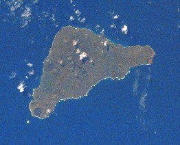
Easter Island is an island in the south Pacific Ocean belonging to Chile. Located 3,600 km (2,237 statute miles) west of continental Chile and 2,075 km (1,290 statute miles) east of Pitcairn Island, it is the most isolated inhabited island in the world. The island is approximately triangular in shape, with an area of 163.6 km² (63 sq. miles), and a population of 3,791 (2002 census), 3,304 of which live in its capital city Hanga Roa. The island is famous for its numerous moai, thousand-year-old (approx.) stone statues now located along the coastlines. Modern Easter Island has virtually no trees.


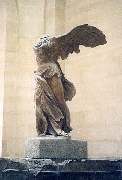
Moai are statues carved of compressed volcanic ash on Rapa Nui (Easter Island). The statues are all monolithic, that is, carved in one piece. However, less than about one-fifth of the statues that were moved to ceremonial sites and then erected once had red stone cylinders pukau placed on their heads. These "topknots," as they are often called, were carved in a single quarry known as Puna Pau. About 95% of the 887 moai known to date were carved out of compressed volcanic ash at Rano Raraku, where 394 moai still remain visible today. Recent GPS mapping in the interior will certainly add additional moai to that count. The quarries in Rano Raraku appear to have been abandoned abruptly, with many incomplete statues still in situ. However, the pattern of work is very complex and is still being studied. Practically all of the completed moai that were moved from Rano Raraku and erected upright on ceremonial platforms were subsequently toppled by native islanders in the period after construction ceased.

Although usually identified as "heads" only, the moai are actually one piece figures with heads and truncated torsos.

The most widely-accepted theory is that the statues were carved by the Polynesian colonizers of the island beginning by about A.D. 1000-1100. In addition to representing deceased ancestors, the moai, once they were erect on ceremonial sites, may also have been regarded as the embodiment of powerful living chiefs. They were also important lineage status symbols.

November 03, 2005

The Louvre Museum


The Louvre Museum
Location: 48 51' 39.90" N 2 20' 08.80" E (Copy&Paste in Google Earth)

The Louvre Museum (Musée du Louvre) in Paris, France, is one of the largest and most famous museums in the world. The building, a former royal palace, lies in the centre of Paris, between the Seine river and the Rue de Rivoli. Its central courtyard, now occupied by the Louvre glass pyramid, lies in the axis of the Champs-Élysées, and thus forms the nucleus from which the Axe historique springs. Part of the royal Palace of the Louvre was first opened to the public as a museum on November 8, 1793, during the French Revolution.

The Louvre holds the rich artistic heritage of the French people from the early Capetian Kings through the Empire of Napoleon Bonaparte and to the present day.

Long managed by the French state under the Réunion des Musées Nationaux the Louvre has recently acquired powers of self-management as an "Etablissement Public Autonome" in order to better manage its growth.

Among the thousands of priceless paintings is the Mona Lisa, perhaps the most famous painting in the world; it is housed in the Salle des Etats in a climate-controlled environment behind protective glass. Works of artists like Fragonard, Rembrandt, Rubens, Titian, Poussin, David, and Leonardo da Vinci can also be seen. Among the well-known sculptures in the collection are the Winged Victory of Samothrace and the Venus de Milo.

Mona Lisa
Mona Lisa
Winged Victory of Samothrace
Venus de Milo
Venus de Milo

Palace of Versailles


Palace of Versailles
Location: 48 48' 15.34" N 2 07' 19.50" E (Copy&Paste in Google Earth)

The Château de Versailles —or simply Versailles— is a royal château, outside the gates of which the village of Versailles, France, has grown to become a full-fledged city. From 1682, when King Louis XIV moved from Paris, until the royal family was forced to return to the capital in 1789, the court of Versailles was the center of power under the Ancien Régime. Those who are not French tend to call it the "Palace".


Louis XIII often hunted in the woods of Versailles, and had a hunting lodge built there in 1624. In 1627 he entrusted Jacques Lemercier with the plan of a château.

In 1660, Louis XIV, coming to majority and taking on full royal powers, was casting about for a site near Paris but away from the tumults of the city. He had grown up in the disorders of the civil war between rival bands of aristocrats called the Fronde and wanted a site where he could organize and completely control a government of France centered upon his person. He settled on the lodge and decided to convert it into a palace. In 1661 Louis Le Vau made some additions which were further developed by him in 1668. In 1678 Mansart took over the work, the Galerie des Glaces, the chapel and the two wings being due to him. On May 6, 1682 Louis XIV took up his residence in the château.

The château was largely completed by 1688. The team of architect Louis Le Vau, decorator Charles Le Brun and garden designer André Le Nôtre had been assembled by Louis' own finance minister Nicolas Fouquet at Vaux-le-Vicomte, whose grand success there was his undoing.

After Louis XIV, several smaller buildings were added to the park of Versailles by Louis XV and Louis XVI including the Grand Trianon, the Petit Trianon, and the Hamlet of Marie Antoinette known as the Petit hameau, which, in a way, is one of the world's first open air museums. - Wikipedia

November 01, 2005

Stonehenge


Stonehenge
Location: 51 10' 42.15" N 1 49' 31.6" W (Copy&Paste in Google Earth)


Stonehenge is a Neolithic and Bronze Age monument located near Amesbury in the English county of Wiltshire, about 8 miles (13 km) northwest of Salisbury. It is composed of earthworks surrounding a circular setting of large standing stones, known as megaliths. There is some debate about the age of the stone circle, but most archaeologists think that it was mainly constructed between 2500 BC and 2000 BC. The older circular earth bank and ditch, which constitute the earliest phase of the monument, have been dated to about 3100 BC.

The site and its surroundings were added to the UNESCO's list of World Heritage Sites in 1986. It is also a legally protected Scheduled Ancient Monument. The monument itself is owned and managed by English Heritage whilst the surrounding downland is owned by the National Trust.

Stonehenge is located at 51° 10′ 43.9″ N, 1° 49′ 31.6″ W. - Wikipedia


Overlay with satellite image

London Tower Bridge


Tower Bridge
Location: 51 30' 19.50" N 0 04' 30.50" W (Copy&Paste in Google Earth)

Tower Bridge is a bascule bridge in London, over the River Thames. It is close to the Tower of London, which gives it its name. It is occasionally incorrectly referred to as London Bridge, which is the next bridge upstream. The bridge is owned and maintained by Bridge House Estates, a charitable trust overseen by the Corporation of London. - Wikipedia

Tower of London


Tower of London
Location: 51 30' 29.00" N 0 04' 32.90" W (Copy&Paste in Google Earth)

The Tower of London is officially Her Majesty's Palace and Fortress, The Tower of London, although the last ruler to reside in it as a palace was King James I (1566-1625). The White Tower, the square building with turrets on each corner that gave it its name, is actually in the middle of a complex of several buildings along the River Thames in London, which have served as fortress, armoury, treasury, mint, palace, place of execution, public records office, observatory, refuge, and prison, particularly for upper class prisoners. This last use has led to the phrase "sent to the Tower" meaning "imprisoned." Elizabeth I was imprisoned for a time in the Tower during her sister Mary's reign; the last use of the Tower as a prison was during World War II, for Rudolf Hess. - Wikipedia

Yeoman Warder

London Eye


London Eye
Location: 51 30' 11.00" N 0 07' 10.40" W (Copy&Paste in Google Earth)

The British Airways London Eye, sometimes called the Millennium Wheel is the first-built and largest observation wheel in the world (a type of or evolution on the Ferris wheel), and has been since its opening at the end of 1999. It stands 135 metres (443 feet) high on the western end of Jubilee Gardens, on the South Bank of the River Thames in Lambeth, London, England, between Westminster and Hungerford Bridges. It is adjacent to London's County Hall, and stands opposite the offices of the Ministry of Defence situated in Westminster which it overlooks to the west. - Wikipedia

Big Ben


Big Ben
Location: 51 30' 02.60" N 0 07' 27" W (Copy&Paste in Google Earth)

Big Ben is the colloquial name of the Clock Tower of the Palace of Westminster in London, and an informal name for the Great Bell of Westminster, the largest bell in the tower and part of the Great Clock of Westminster.

The clock tower is at the north-western end of the building, the home of the Houses of Parliament, and contains the famous striking clock and bell. - Wikipedia

The Colosseum


The Colosseum
Location: 41 53' 24.70" N 12 29' 32.20" E (Copy&Paste in Google Earth)

The Colosseum or Coliseum, originally known as the Flavian Amphitheatre (lat. Amphitheatrum Flavium), is an amphitheatre in Rome, capable of seating 50,000 spectators, which was once used for gladiatorial combat. Construction was initiated by Emperor Vespasian and completed by his sons, Titus and Domitian, between AD 72 and AD 90. It was built at the site of Nero's enormous palace, the Domus Aurea. The Colosseum's name is derived from a colossus (a 130-foot, or 40-metre, statue) of Nero which once stood nearby. - Wikipedia

Vatican City


Vatican City
Location: 41 54' 08" N 12 27' 26" E (Copy&Paste in Google Earth)

Vatican City — formally State of the Vatican City, or Vatican City State (Latin: Status Civitatis Vaticanæ and Italian: Stato della Città del Vaticano) — is an ecclesiastical sovereign landlocked enclave surrounded by Rome, Italy. The modern-day home of the popes, it is the smallest independent nation state in the world in terms of area and population. It is administered by the Holy See, the ecclesiastical seat of the Roman Catholic Church and its Eastern Rites.

The Head of State is the Pope; the Heads of Government are the Secretary of State and Governor of Vatican City (sometimes referred to as the President of Vatican City). Currently, they are Pope Benedict XVI, a German; Angelo Cardinal Sodano, an Italian; and Edmund Cardinal Szoka, an American of Polish descent. The governance of the Holy See is separate, consisting of the Roman Curia, in turn consisting of members of the College of Cardinals. The Heads of Government are concurrently agents of the Roman Curia.

The city takes its name from the Latin Mons Vaticanus, Vatican Hill. Mons Vaticanus, and the adjacent Vatican Fields upon which St. Peter's Basilica and its Sistine Chapel, Apostolic Palace and museums were built, predates Christendom. -Wikipedia

Leaning Tower of Pisa

Leaning Tower of PisaLeaning Tower of Pisa

Leaning Tower of Pisa
Location:43 43' 22.60" N 10 23' 47" E (Copy&Paste in Google Earth)

The Leaning Tower of Pisa (Italian: Torre pendente di Pisa) is the campanile, or bell tower, of the Italian city of Pisa's cathedral.

The tower was intended to stand vertically, but began leaning soon after construction started in August of 1173. It is situated behind the Cathedral and it is the third structure in Pisa's Campo dei Miracoli (field of Miracles).

The height of the tower is 55.86 m from the ground on the lowest side and 56.70 m on the highest side. The width of the walls at the base is 4.09 m and at the top 2.48 m. Its weight is estimated at 14,500 tonnes. The current inclination is about 5.5 degrees. The tower has 294 steps. - Wikipedia